GOSHEN COUNTY WEED AND PEST CONTROL DISTRICT
  • Home
  • How do I...?
    • Identify what's in my yard
    • Obtain an applicator license
    • Dispose of hazardous waste
    • Know how much chemical to put in my sprayer
    • Certify/buy weed-free products
    • Get my weeds sprayed
    • Attend a board meeting
    • Apply for a job
  • Programs & Services
    • CRM Program
    • Mosquito Program
    • Leafy Spurge
    • Dalmatian Toadflax
    • Prairie Dogs
    • Spraying Services
    • AGREEMENTS
  • Weeds & Pests
    • Thistle Guide
    • Common Weeds & Pests
    • Early Detection, Rapid Response
    • State Designated Species
    • County Declared Species
  • News & Resources
    • Newsletter
  • Our Team

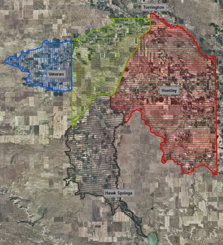
Coordinated resource management

The Coordinated Resource Management (CRM) project began in 1994 to manage and control the growing noxious weed issues in Goshen county through long-term IPM goals and solutions. The areas of focus are rangeland, riparian, recreation, and wildlife habitat areas.

What does it all mean?

​The CRM helps me convince neighbors to also control their weeds so my efforts aren't futile
This program allows me to purchase chemical I couldn't otherwise afford
Picture
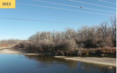
Russian olive trees along North Platte River prior to control
Picture
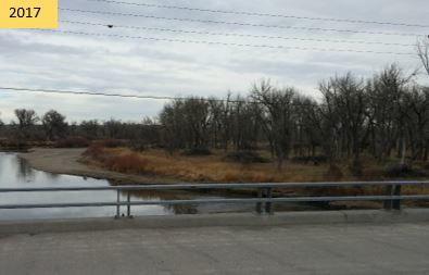
Slash piles shown after removal of Russian olive within CRM

CRM AREAS

Certain areas within Goshen County are at a higher risk for weed invasions and spread. These locations tend to be along a waterway or drainage which carry weed seeds. Equipment, animals, and people also contribute to the movement of noxious weeds. There are a total of six areas within the county which are in the CRM project.

  • Area 1 (gray): North/West - Hawk Springs Ditch; East - Horse Creek; South - Hawk Springs Reservoir
  • Area 2 (red): North - North Platte River; East - WY/NE state line; South - Horse Creek; West - U.S. Highway 85
  • Area 3 (blue): North/South/West - Fort Laramie Canal; East - Highway 154
  • Area 4: Russian Olive and Salt Cedar throughout the county, but mainly along the North Platte River
  • Area 5 (yellow): South of the North Platte River; see Dalmatian toadflax project page
  • Area 6 (green): North - Fort Laramie Canal; East - U.S. Highway 85; South - Hawk Springs Ditch; West - Highway 154
Picture
Picture

Cost-share

GCWP believes these are high-risk areas for spread and infestation of noxious weeds. To mitigate these risks, we encourage and support landowners to control weeds by offering a cost-share up to 50% on $1,000.
  • All treatment programs MUST be pre-approved by GCWP in order to be considered for cost-share reimbursement.
  • If landowners hire an outside entity (i.e. GCWP, Westco, Simplot) to spray weeds, we will reimburse 50% the cost of the application of not more than $1,000 total bill.
  • If landowners wish to purchase chemical from GCWP and apply this chemical with their own labor, the landowner labor will be considered 50% contribution to the total bill.
  • An agreement between GCWP and the landowner must be on file prior to treatment. Please read through this agreement document below.
CRM Agreement
Contact:
(307) 532-3713
​[email protected]
Picture
Picture
Proudly powered by Weebly
  • Home
  • How do I...?
    • Identify what's in my yard
    • Obtain an applicator license
    • Dispose of hazardous waste
    • Know how much chemical to put in my sprayer
    • Certify/buy weed-free products
    • Get my weeds sprayed
    • Attend a board meeting
    • Apply for a job
  • Programs & Services
    • CRM Program
    • Mosquito Program
    • Leafy Spurge
    • Dalmatian Toadflax
    • Prairie Dogs
    • Spraying Services
    • AGREEMENTS
  • Weeds & Pests
    • Thistle Guide
    • Common Weeds & Pests
    • Early Detection, Rapid Response
    • State Designated Species
    • County Declared Species
  • News & Resources
    • Newsletter
  • Our Team